Press notes 22/11/2022
URV researchers and students collaborate in the Archaeological Park and Landscape of the Roman City of Clunia
The students have taken part in the excavation campaign this year and the researchers are studying the organisation of one of the most important cities in the province of Tarragona using satellite, drone and thermal camera images

The students have taken part in the excavation campaign this year and the researchers are studying the organisation of one of the most important cities in the province of Tarragona using satellite, drone and thermal camera images
The Roman city of Clunia (province of Burgos) has one of the largest Roman theatres in the Peninsula. It belonged to the provincial court of Tarraconensis, in Roman Spain, and was the capital from which Galba emerged as emperor after he rose up against Nero.
A team of researchers from the URV’s Department of History and Art History is working with other universities on the excavations led by the Clunia Research Team and the Burgos Provincial Council. They have two aims: to provide insight into the organisation of the city so that it can be assessed and understood by society, and to facilitate student learning in the field.
Clunia covers an area of 130 hectares, but only one-sixth of the whole site has been excavated, including the theatre, the forum, the baths and the basilica. Now, the researchers from the URV and other universities are focusing on exploring areas that have not been studied to date using non-invasive prospecting techniques to determine how they were structured.
Students’ field work
As well as the non-invasive prospection, the undergraduates studying History of Art and Archaeology, together with the undergraduates from the universities of Burgos and Valladolid, have once again taken part in the excavation after the a long lay off because of the pandemic. In this autumn’s campaign they have excavated the porticoes of the forum in Clunia and the basilica.
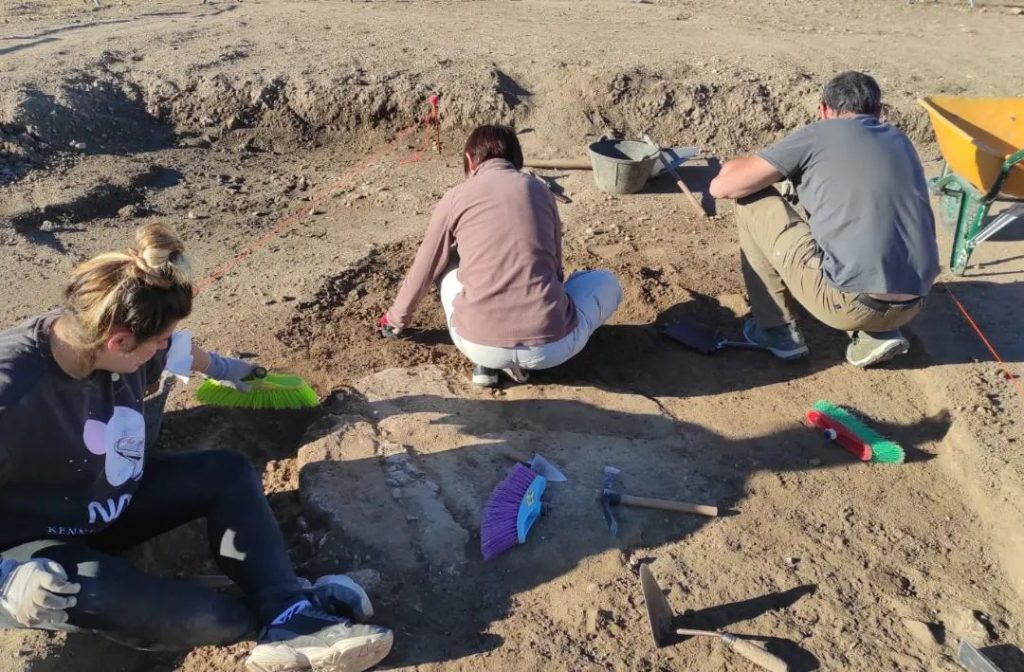
Ignacio Fiz, a researcher from the Department of History and History of Art, explains that the students were responsible for “uncovering the strata and classifying them, finding material, cleaning it, classifying it and studying it.” Thanks to them, visitors to the site, which is open to the public, can now see the foundations of the portico in the forum and also the communication between the portico and the basilica, which had not been clear until now.
The URV researchers began to work on the Clunia excavations more than 20 years ago, with the particular involvement of one of the researchers, Eva Subias. The research is directed by María Rosa Cuesta Moratinos (Burgos Provincial Council), Francesc Tusset (University of Barcelona) and Miguel Ángel de la Iglesia (University of Valladolid).
Non-invasive prospection
The URV research team (Ignacio Fiz, Eva Subias, Joaquin Ruiz de Arbulo and Pere Manel Martín) contributed to the research by prospecting the land using a combination of non-invasive methods. They documented part of the site using aerial photogrammetry, which enabled them to build a 3D model of the area. Thanks to the aerial photography, and the use of thermal and infrared cameras, which highlight details of the terrain, they have detected possible underground structures that are still being studied and reviewed by researchers from the Clunia Research Team.
They have also worked with multispectral and radar images obtained from satellites. In this case, unlike the commonly used three-band (RGB) photographs, the band frequency of multispectral images (e.g. infrared) is not visible to the naked eye. However, once processed, it reveals the valuable information of the terrain, which may be associated with the existence of underground structures.
This methodology was first used by the Department of History and History of Art about 10 years ago, and the results have been published in three scientific articles: “We are experimenting with various techniques and combining results to prove that we can reveal what we cannot see by other means. In this way we hope to shed light on the urban structure of a sector of the city that has not yet been excavated,” explains Ignacio Fiz.
They are now studying the results obtained, and hope to identify structures in Clunia, the only evidence of which comes from 18th-century cartography. They have also used the technique at other sites such as Puig Rom (Roses, Catalonia), Vilanera (L’Escala, Catalonia), and Cosa (Ansedonia, Italy).
Bibliographic references
Fiz, Ignacio, Rosa Cuesta, Eva Subias, and Pere Manel Martin. 2021. “Tests with SAR Images of the PAZ Platform Applied to the Archaeological Site of Clunia (Burgos, Spain)” Remote Sensing 13, no. 12: 2344. DOI: https://doi.org/10.3390/rs13122344
Fiz, José Ignacio, Pere Manel Martín, Rosa Cuesta, Eva Subías, Dolors Codina, and Antoni Cartes. 2022. “Examples and Results of Aerial Photogrammetry in Archeology with UAV: Geometric Documentation, High Resolution Multispectral Analysis, Models and 3D Printing” Drones 6, no. 3: 59. DOI: https://doi.org/10.3390/drones6030059
Cuesta, Rosa; Fiz Fernández, Ignacio; Subías Pascual, Eva; Tuset, Francesc; Iglesia, Miguel Ángel de la. (2019) . Hydraulic and urban management during Roman times based on GIS and remote sensing analysis (Clunia, Spain). Revista d’arqueologia de Ponent, 2019, núm. 29, p. 123-146. DOI: https://doi.org/10.21001/rap.2019.29.4.
