02/05/2024
The European project MobiDataLab revolutionises the processing of mobility data
They have created a centralised database with mobility information from the main European cities and have established standards for obtaining, using and sharing the data. The CRISES group of the URV has guaranteed the privacy of the most sensitive data

They have created a centralised database with mobility information from the main European cities and have established standards for obtaining, using and sharing the data. The CRISES group of the URV has guaranteed the privacy of the most sensitive data
After three years, the European MobiDataLab project has come to an end with promising results. The URV’s CRISES research group has worked hand in hand with various European organisations specialising in data analysis and processing with the aim of improving mobility in cities. More specifically, URV researchers have developed the means of ensuring data privacy of the users from whom the most sensitive mobility data are obtained before these are published. The MobiDataLab project has managed to create a platform that brings together the mobility data of some of the main European cities, to establish standards in the collection, processing and sharing of the data and to carry out practical sessions based on real cases to optimise mobility in cities.
Urban mobility is a key aspect in the quality of life of people who live in cities and for the economic development of the companies that operate in them. According to World Bank data, more than half of the world’s population lives in cities and this percentage is expected to rise to 70% by 2050. Given this, it is crucial to provide institutions and researchers with tools to optimise mobility in urban environments. So far, each organisation has decided what data it uses and how it uses it, making it difficult to pool this information in a single database and, consequently, to use it in research.
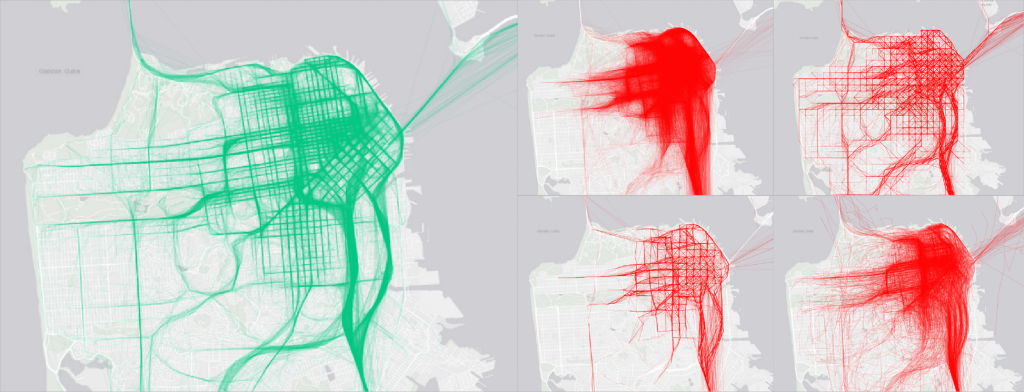
In this context, MobiDataLab participants have worked to promote the sharing of mobility data between interested institutions and organisations, building a platform that brings together data for easy access. It is designed in such a way that it does not need to be fed manually, but rather obtains information from different European institutions – more than 115,000 sets of data – and places it in a unified catalogue. They have also designed and implemented a guide with recommendations and best practices for data collection and processing, with the intention of facilitating data grouping and enhancing it usability.
During the final phase of the project, the new database was made available to work teams of researchers and students who were asked to solve a series of challenges to improve mobility in various European cities. Among the challenges were defining new pedestrian lanes to improve urban accessibility in Paris and optimising the flow of vehicles in the centre of Milan during the city’s major events. One of the outstanding solutions consisted of creating an algorithm capable of determining the ideal location of public transport stations based on traffic and demographic data, parking availability, the location of cycle lanes, etc. It is estimated that, if this technique were implemented in the city of Leuven, carbon dioxide emissions could be reduced by 22%.
Ensuring data privacy
Many of the mobility data used are public, for example, the location of bus stops, the frequency of trains on a given metro line, the number of cars passing through an intersection, etc. Other data, however, have the potential to identify individuals and the routes they usually take by means of geolocation. “There are not many people who leave your street every day and walk to the building where you work”, reflects Jesús Manjón, researcher at the Department of Computer Engineering and Mathematics. Personal mobility data is particularly sensitive and needs to be protected so that it does not fall into the hands of third parties (hackers, private companies, institutions, etc.) without the user’s consent.
Researchers from the CRISES research group created a module to anonymise this type of data before it is made public and make any subsequent personal identification impossible. “It is a delicate process; during anonymisation there is a risk of diminishing the usefulness of the data,” explains Manjón. To check the correct functioning of the module, data from more than a million trajectories involving more than fifty million geolocations were anonymised and the teams of researchers and students who had been working on the mobility challenges were challenged to find the end of any personal data, which turned out to be impossible.
The project will bring together ten partners from various sectors, such as industry, research, consultancy and governance, in seven European countries (France, Italy, Greece, Germany, Belgium, Ireland and Spain). The institutions involved share a commitment to open data and open-source principles, with a focus on scalability and replicability beyond the EU. MobiDataLab is funded by the EU under the Research and Innovation Programme.
